Extreme weather events are increasing in frequency and intensity, whilst climate change projections point towards further, largely negative, impacts on humans and nature. In response, climate change adaptation has become a stronger component of policy agendas globally. As part of this response, climate risk assessments are routinely undertaken across a wide variety of sectors and spatial scales. In this article, Dr Jeremy Carter argues the case for such assessments to embed into green infrastructure (GI) decision making, to support the planning, design and maintenance of GI in a future characterised by a changing climate.
- Green infrastructure is critical to urban areas – but it is also at risk from the changing climate.
- A study from The University of Manchester on grassed areas in Greater Manchester is the first of its kind case of a spatial, at scale related risk assessment.
- This research highlights that analysing and spatially visualising patterns of extreme weather and climate change risk to urban GI can support planning and decision making.
Green infrastructure is at risk from climate change
There is growing evidence of the environmental, economic and social benefits offered by GI to urban areas. As a result, policy frameworks at national and local levels commonly advocate GI measures, and there is increasing recognition that GI should be considered a form of critical infrastructure alongside the likes of transport, water supply and electricity generation infrastructure.
These forms of critical infrastructure are impacted by extreme weather and climate change hazards. Because of this, related risks are commonly assessed, and adaptation responses are subsequently implemented in an effort to maintain the services that they provide to society. For example, identification of risk to rail lines from flooding and sea level rise helps to target measures needed to protect the network from such hazards.
Researchers are only just beginning to consider climate risks to GI, often focusing on current weather extremes rather than future climate change projections. Examples include studies exploring how high temperatures and drought conditions impact urban trees and woodlands, which have identified negative impacts including reductions in leaf cover and increased exposure to pest species. Soil moisture deficits can also stress urban grassed areas, leading to dieback of grasses.
These impacts can, in turn, compromise the ability of urban GI to provide the benefits and services it is valued for, notably those linked to adaptation to climate change such as cooling air and surface temperatures and enabling rainwater capture and absorption.
Green infrastructure risk assessment – our research study
Despite the threat that climate change poses to urban GI, approaches to assess related risks spatially, at a scale that can inform local decision making, are not available. A recent study involving researchers based at The University of Manchester represents the first example of such a risk assessment.
The study assessed risk to Greater Manchester’s (GM) grassed areas from an extended period of low water availability. Grassed areas are an important element of GM’s urban GI and are more susceptible to harm from water deficits than trees.
The year 2018 was selected to base the risk assessment around. A high-pressure system over the UK during the summer of 2018 brought exceptionally high temperatures and low rainfall – conditions projected to become more common in GM with the intensification of global heating. This offered the ideal case study to explore climate change related risks to grassed areas across the city-region.
Greater Manchester grasslands – spatial risk assessment
This study identified specific areas of GM’s grasslands where there is a high risk of grasses dying back under conditions of low water availability.
Soil characteristics linked to their capacity to hold water stand out as a key factor in determining levels of risk. Also, being surrounded by highly built-up urban landscapes makes grassed areas more sensitive to low water availability as this reduces the water recharge capacity of soils, thereby intensifying levels of risk.
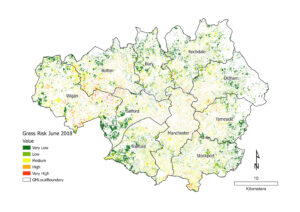
However, to help maintain their functionality under such conditions, grassed areas can be irrigated with ground water. The presence of ground water close to the surface indicates higher capacity to adapt to low water availability conditions, and therefore presents the opportunity to moderate the severity of associated risks posed to grassed areas. These factors were evaluated at a fine scale to generate a spatial assessment of risk to GM’s grassed areas from low water availability (see Figure 1).
Figure 1: Risk to Greater Manchester’s grassed areas from low water availability conditions in June 2018. (Source: Carter, J.G., Labib, S.M., Mell, I. 2024. Understanding and Assessing Climate Change Risk to Green Infrastructure: Experiences from Greater Manchester (UK). Land, 13 (5), 697.)
Implications, interventions and inequalities
A key role of GM’s GI is reducing fluvial (from rivers and streams) and pluvial (excess surface water runoff that exceeds the capacity of natural and manmade drainage systems) flood risk. This is because it can capture and absorb rainwater, thereby reducing the volume of water reaching rivers and streams, delaying flood peaks, moderating the extent of surface water runoff and ultimately reducing flood risk.
These GI functions are negatively impacted by conditions of low water availability as grasses die back, exposing underlying soils which dry out and harden. This is concerning for GM, where flooding is a key hazard facing the city region. Intense rainfall events during the summer months, which has the potential to cause flash flooding, is a specific threat. The risk assessment output (Figure 1) enables targeted interventions to reduce this risk in areas of greatest need, for example where GI at high risk from low water availability is located in built up areas threatened by pluvial flooding.
This study also identified that grassed areas within the most highly deprived areas of GM were more likely to be at high risk from low water availability conditions compared to grassed areas within GM’s least deprived areas. This is indicative of broader socioeconomic inequalities concerning access to urban GI. Given the role that GI can play in enhancing health and wellbeing, there is a requirement for planners and decision makers to ensure that GI in areas suffering from deprivation is adapted to climate change.
Ways forward for green infrastructure
Enhancing the resilience of GI to climate change should be considered consistently and systematically, not just in GM but in cities and urban areas across the world.
New GI investments and interventions need to be climate resilient, especially as the likes of public gardens and street trees are long lasting features of urban environments. Specific approaches that should be considered include providing capacity to irrigate GI and developing planting schemes that are more resistant to low water availability.
Concerning existing GI resources, our mapping exercise described above can help to prioritise where local interventions should take place, and this approach could usefully be developed and rolled out to other local authorities. Irrigation approaches are an important part of the response, as are schemes to modify surface cover, e.g. planting trees within grassed areas. Such interventions should be prioritised in areas of social and economic deprivation, where additional benefits can be captured from enhancing GI resources.
Policy direction is needed at the national level, particularly from the Ministry of Housing, Communities and Local Government, to stimulate local planning authorities to recognise and act to reduce the risk of climate change to urban GI. Organisations such as Natural England must also help to build knowledge and awareness of climate change risk amongst GI stakeholders.
This is crucial, given the threat of climate change to GI, and the need to maintain and enhance the benefits and services that this form of critical infrastructure can offer to urban areas over the coming decades.

